LEE VALLEY REGIONAL PARK PLAN 2000
SECTION SEVEN: CLAPTON TO STRATFORD |
Setting the Scene
The key feature of Section Seven is the green character and
openness of the valley which exists in sharp contrast to the
surrounding urban and industrial environment. The open spaces are
a substantial size and for the most part, they form a continuous
inter-related open area for leisure and recreation. The area is well
used and busy with diverse recreational activities, indoor and
outdoor sports, events and general enjoyment of the wildlife
interest. The waterways of the Lee Navigation and the River Lea,
enhance the leisure and wildlife spaces and provide further
opportunity for water sports, habitat creation and informal
recreation.
|
Key Resources and Special Features
This Section incorporates an impressive range of open spaces and
high quality habitats. The valuable Walthamstow Marsh for example,
which has survived without destruction by land fill or conversion to
playing fields, is a Site of Special Scientific Interest (SSSI) and nature
reserve with both ecological and heritage interest. The association of
this natural open space with the mature parkland at Springfield
Park, the Lee Navigation and Springfield Marina, which are all of
good quality visually, help to give the northern part of this area its
well-defined and positive character. The openness continues
through to the south of the Section where the green recreational
spaces at the Lee Valley Cycle Circuit, Bully Point and Bully Fen are
protected for their nature conservation value. The waterways are
also recognised as key wildlife habitats and as green corridors
between sites. In the south, the towpaths alongside the waterways
form linear extensions to the Regional Park. They provide links
through to the adjoining built up areas and create access routes into
the Park. Nature conservation resources and industrial heritage
interests combine at the Middlesex Filter Beds Nature Reserve and
within the Essex Filter Beds site, with remnants of the water
industry and wetland habitats providing themes around which to
base visitor attractions and innovative nature conservation sites.
Besides Springfield Park, there are several other parks that
contribute to the open space resource of the Regional Park,
including St James' Park and North and South Millfields Recreation
Ground. Mature trees at these locations and along Lea Bridge Road
all help to create a pleasant green character. The open spaces of the
Low Hall playing fields and the nature conservation interest at the
Low Hall Flood Meadow are a valuable addition to the open and
green character of the Park, although these areas require
enhancement and further integration with the rest of this Section.
Further south, the predominant land use within the Regional Park
is the vast, flat, open area of Hackney Marsh, comprised of
numerous sports pitches. Embraced by the River Lea to the east
and the Lee Navigation along the western edge, with lines and belts
of mature poplar trees, the surrounding industrial and urban
development is well screened from the central areas of the Marsh.
The taller buildings of the City can be viewed in the distance.
Construction of the A12 to M11 link road has had a major impact on
the southern reaches of the Marsh, separating a number of smaller
parcels of open space from the main area. Further landscape
enhancement of Hackney Marsh, drawing on the intimate and
attractive areas that exist along the periphery is needed. This would
consolidate the importance of this huge green space within such an
urban environment and its role in providing for both sporting
activity and casual recreation. |
 |
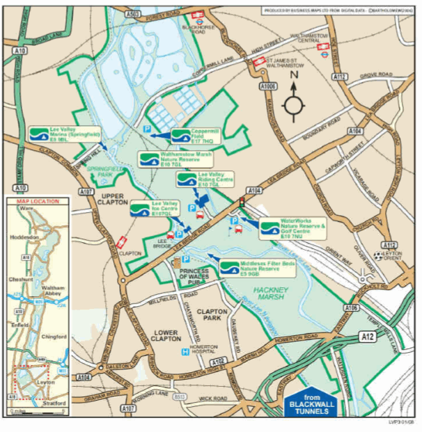
| Park Plan map: Clapton to Stratford
Numbers refer to proposals in this document | |
Opportunities for Visitor Enjoyment
The major part of Section Seven is freely open for public recreation
and this forms the predominant land use throughout. Most of the
resources serve regional catchments and the open spaces and the
built facilities cater for and are used intensively for a variety of
activities from, for example, ice skating to competitive cycling, and
team sports to nature study and walking. There are a number of
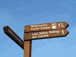
leisure centres, such as the Lee Valley Riding Centre and Lee Valley
Ice Centre at Lea Bridge Road and the Lee Valley Sports Centre at
Eastway. Other specialist leisure facilities exist at Hackney Stadium
and the Lee Valley Cycle Circuit. Facilities at Springhill and
Springfield Marina provide for water sports and recreation. Golf is
available at the Lee Valley 18 Hole Par 3 Golf Course near Lea Bridge
Road. Between the open spaces and sports fields at Low Hall and
Springhill, are the rich wetland, marsh and grassland habitats of
Walthamstow Marsh Nature Reserve which is managed to
encourage access to and enjoyment of the wildlife. Informal
recreation is also accommodated at Hackney Marsh as well as its
intensive use for outdoor sports. Educational activities also occur
within the area making use of the nature conservation, water and
open space resources.
Visitor facilities are available mainly on the periphery of the Regional
Park, in the form of local pubs and waterside cafes. Local and
regional events are held at the leisure centres and on the open
spaces. A small permanent camp site at Eastway Cycle Circuit and
a temporary one on Hackney Marsh provide budget accommodation
within the Regional Park. Proposals identify opportunities for new
visitor facilities at Lea Bridge Road associated with the regeneration
and enhancement of the Essex Filter Beds as a nature reserve.
Further facilities are needed however, especially given the extent of
this Section. Under-used land, vacant sites and areas in non
compatible use could provide the opportunities in the future.
Development at Stratford associated with the Channel Tunnel Rail
Link should create the impetus for new leisure facilities, including
hotels. Although outside the Regional Park, such development could
benefit visitor enjoyment of the open spaces and recreational sites.
There is reasonable access into the Regional Park from its western
edge with pedestrian, cycle and bus routes along Lea Bridge Road
and with various direct connections to the local community and the
benefit of north-south links along the Lee Navigation towpath. From
the east, access for pedestrians and cyclists is more limited.
Improvements are taking place throughout the Section and
Proposals seek to identify measures such as new bridges, the
provision of safe road crossings and cycle lane provision. Clapton
Station, Hackney Wick Station and Stratford Station, although just
outside the Park, do offer the potential to reach the Park by rail.
Buses also pass through although their services are often not the
most convenient for leisure users. In the future, development of an
International Passenger Station at nearby Stratford offers scope to
both improve and promote access on a large integrated scale with
potential to create a new gateway into the Regional Park.
Proposals
Proposals aim to protect the openness of Section Seven and the
huge and varied recreational resource this represents. They aim to improve the quality of the landscape and existing facilities in order
to combat the intrusion of large-scale industrial uses which lie
adjacent to the Regional Park. Wider use of recreational facilities
and spaces is a key objective and this Section can accommodate a
high level of use and offer a wide variety of choice. Proposals aim to
achieve this wider variety and greater visitor numbers through
interpretation, refurbishment of built facilities, events,
improvements to signage and access and through the development
of new visitor centres and facilities where this can be achieved
without intruding upon the openness of the valley.
|
|
|
SECTION SEVEN: PROPOSALS
7 Area providing for a high capacity of recreational and
sporting use based on extensive open spaces and built
leisure facilities with outstanding ecological and heritage
resources available for visitor enjoyment.
In addition to the Strategic Proposals LVRP1-4 and Parkwide
Proposals, specific Sectionwide Proposals which
contribute to the achievement of the Vision for the Regional
Park are:
a The recreational and sporting use of open spaces and
parkland to be protected and encouraged.
b The quality of established facilities for sport and leisure to
be improved and modernised. Redevelopment of built
leisure facilities to use the existing footprint, so as to
maintain the open character of the area.
c The openness and green character of the recreational
spaces and local parks to be protected with vacant sites
incorporated into the wider landscape enhancement of the
area and brought into recreational use.
d Geological and historical features of special interest within
the landscape to be conserved and interpreted and views to
key landmarks within and outside the Regional Park
protected.
e Pedestrian and cycle access to be enhanced through
** the improvement of links between the Regional Park
and public transport nodes;
** the implementation of the Lee Valley Line Proposal;
** the co-ordination and improvement of public
transport to ensure safe and regular services to and
from leisure sites and facilities; and
** the creation of stronger visual and physical links
between sites and the provision of clearly signposted
entry points into the Regional Park from the west and
the east.
f The effect of railway embankments that cross the Regional
Park to be softened through landscape works whilst
ensuring views out across the Park are maintained.
g The adverse impact of major highways through and
alongside the Regional Park to be reduced through
** traffic controls and traffic calming;
** appropriate planting and maintenance of green road
frontages;
** maintenance of views into the Regional Park; and
** development of safe crossing points and physical
linkages between sites on either side of the road.
h Encouragement to be given to landowners of industrial
buildings which abut and lie within the Regional Park, to
improve landscape and boundary treatments, maintain
buildings and other structures and ensure all activity is
contained within their sites, so that they make a positive
contribution to the image of the Park.
i The upkeep and appearance of pockets of residential
development within the Regional Park to be maintained to
a high standard.
j Major redevelopment within the Stratford Rail Lands to the
east of the Regional Park to be planned and implemented
so as to achieve an increase in the extent of the open green
space of the valley, the creation of new pedestrian and cycle
links which connect into the Park, and the provision of
complementary leisure and visitor services of high quality
and design.
|
SECTION SEVEN: EXPLANTIONS
Park Plan Part One policies provide guidance on the implementation of proposals
in this Section, in particular: L1.1-L4.4, LS1.2-LS5.5, NC2.1-NC2.6, W2.1-W4.1,
CHR1.2-CHR2.1, WR2.3, IR2.1, IR2.2, IR2.4-IR2.11, FR1.3-FR3.1, CH2.3-CH3.2,
T1.1-T6.3.
Proposals have an indicative status where they refer to land outside the Park, in
particular land forming part of the Stratford Rail Lands.
Within Section Seven, there is a wide range of built leisure facilities, open spaces and
nature conservation sites. These are used and enjoyed by large numbers of people
and accommodate a high capacity or intensive level of recreational and leisure
activity. The ability of these facilities and open spaces to support intensive use
should be both protected and developed and their contribution to the continuity of
the Green Chain should be maintained and enhanced.
Outdoor sporting and recreational facilities and their green setting are to be
safeguarded on the western and eastern edges of the Regional Park (Proposals 7.1,
7.2 and 7.3). The more complex range of outdoor activities, built leisure and
ecological sites to the north and south of Lea Bridge Road are to be enhanced and
promoted as an integrated area for intensive recreational activity and nature
conservation interest (Proposal 7.4). Sporting activity on Hackney Marsh is to be
protected (Proposal 7.5) whilst proposals to upgrade or redevelop existing built sites
to create sporting or leisure facilities of regional significance are identified within the
southern parts of this Section (Proposal 7.6).
Throughout the area the Parkwide proposals of the Landscape Strategy (Proposal
LS), the Water Management Strategy (Proposal WMS), the Waterway Corridor
(Proposal WC7), the Lee Valley Pathway (Proposal PW7) and the Lee Valley Line
(Proposal LVL) are applied.
It is important that the open space and green structure of the landscape is
maintained to a high quality to protect the recreational resource and opportunities
available. Parcels of vacant or underused land give a neglected feel to the area and
need to be brought into a Park compatible use as soon as possible. To the north and
west the mature parkland landscape of Springfield, the Lee Navigation, Millfields
and the natural qualities of Walthamstow Marsh present a well defined and positive
character. This needs to be extended eastwards and further south where industrial
activities adjacent to and within the Park are more intrusive, the Park is more
fragmented, and the pattern of land use is more complex.
Playing fields within the central part of this Section, Site 7.4, have been converted
to recreational open spaces to balance the extensive playing field provision within
Sites 7.5 and 7.6. Proposal 5.3 also provides for active outdoor sport (within Folly
Lane Triangle) where existing sports pitches should be restored.
Pedestrian access into the area needs to be greatly improved. Physical links between
different recreational venues need to be increased to create a stronger image of the
Regional Park. The aim is to project the Park as a wider entity than the many
individual sites.
The visual and aural intrusion of the busy roads and the railways requires a clear
response in terms of landscape to provide at least visual screening and psychological
separation. This would enhance the quality of refuge that the Park provides and
appropriate planting would create clear legible green corridors and greater structure
to the landscape. Busy roads such as Lea Bridge Road, which is one of the main east
west crossings of the Park, and the area around the new A12 to M11 link road have
especial need in this respect. The whole environment of roads through the Park
should be addressed in partnership with local planning and highway authorities, to
create green corridors with clearly signed entrances, improved crossing points for
pedestrians and measures to slow down traffic.
A Combined International and Domestic Passenger Station is to be located at
Stratford as part of the Channel Tunnel Rail Link. Large scale redevelopment and
change is proposed in association with the Station within an area known as the
Stratford Rail Lands, the majority of which lies outside the Park, but also includes
land at Eastway, Site 7.6. The open space and ecological value of the Park area will
need to be protected throughout any development process. Opportunities for new
leisure, improved access and enhanced environment need to be pursued to
demonstrate a balanced and sustainable approach to economic and environmental
regeneration. Other infrastructure improvements, such as the Chelsea Hackney
Line, may also have implications for sites within the southern part of Section Seven.
The Health and Safety Executive advise that account must be taken in the
implementation of Proposals PW7, 7.2, and 7.4 of the constraints arising from the
location of notifiable installations, both within and adjacent to the Park. | |
WC7 Waterway Corridor including Hertford Union Canal
In addition to Park-wide Proposal WC:
a Visitor facilities on or adjacent to the towpath at Springfield
Park, Springfield Marina, Lea Bridge Road and Old Ford
Lock, to be enhanced and promoted as focal points along
the corridor.
b An attractive and sensitively designed waterside leisure
facility at Essex and Eastwood Wharf to be developed as a
new focal point and visitor attraction with the
decontamination and opening up of the infilled oxbow
immediately to the north to create a new waterside location
for recreational use.
c The upgrading and modernisation of recreational and water
based facilities at Springhill and Leaside to be supported
where these increase the level of participation and where
they are sensitively designed and located to minimise
impact on the landscape and ecological interest of the area.
d Water quality to be improved to meet standards for immersion
water sports and sources of water pollution
addressed.
e The ecological interest of Horseshoe Island at Springfield
Marina to be managed to complement the nature
conservation value of the Waterway Corridor and adjoining
sites to the east and south.
f Footpath and cycle route connections with the Corridor to
be provided especially from outside the Regional Park and
from public transport nodes such as Hackney Wick Station
and Clapton Station. Existing links and bridge crossings to
be upgraded and pedestrian and cycle access along the
towpath safeguarded.
g Existing green edges alongside the waterways to be
protected and enhanced and new green edges established
as part of developments adjacent to the water.
|
EXPLANATIONS
WC7 Waterway Corridor including Hertford Union Canal
In the southern part of this Section the Regional Park boundary
follows the towpath, adjacent to the Hertford Union Canal and Lee
Navigation. Therefore the Waterway Corridor proposal has an
indicative status on the waterway itself.
The waterways are the key connecting feature that reinforce the
continuous nature of the Regional Park. Their ecological interest
and informal recreational value should be protected and promoted.
The character, environmental quality and visual amenity of the
Waterway Corridor varies throughout Section Seven often due to
the nature of the route itself and its associated features but also
as a result of the impact of adjoining land uses, and the effect of
rail and road crossings. Improvements to water quality, the
waterside environment and towpath would help to strengthen the
character of the corridor whilst the protection and enhancement
of historic features and existing habitats would retain the
individuality of each of its parts. The water routes are identified in
the Biodiversity Action Plan as a key ecological resource.
More emphasis needs to be placed on the recreational potential of
the waterways. Redevelopment of Essex and Eastwood Wharf, for
example, would provide a key opportunity to establish water
related recreational activities. Those facilities currently servicing
the water-based activities need to be upgraded and co-ordinated
and environmental improvements carried out to benefit the visual
and ecological potential of the whole area.
Old Ford Nature Reserve, although outside the Park, is bounded by
the Waterway Corridor and the River Lea as well as the Greenway
(Proposal PW8) and forms an important ecological resource that
relates to the Park. Opening up some form of managed access to
the site would add interest for visitors travelling along the
Waterway Corridor.
The Waterway Corridor is traversed by a number of road and rail
links that have an adverse impact on the environment and on the
leisure experience of visitors. Development alongside the Corridor
also has a major impact, especially in the south where the
concentration of industrial activity is greatest. This environmental
degradation can only be combated through a combination of
maintenance, landscape, design and ecological improvements and
an insistence on the highest quality of design and build in new
development.
| |
PW7 Lee Valley Pathway Corridor
In addition to the Park-wide Proposal PW:
a In the north, Coppermills Fields to be enhanced and
incorporated into the Corridor for informal recreation use.
b The route of the Lee Valley Pathway to be secured and
provided as part of new development on land within and
adjoining the Regional Park.
c Connecting paths to be established, especially from the
residential and industrial areas in the east and from the
Low Hall area. Key entrance points onto the route to be
created at Coppermill Lane, Lea Bridge Road, Eastway and
Carpenters Road.
|
EXPLANATIONS
PW7 Lee Valley Pathway Corridor
Certain sections of the existing Lee Valley Pathway require
improvement and enhancement, for example through the Lee
Valley Cycle Circuit and Bully Point Nature Reserve and alongside
the River Lea at Stratford Marsh. At other points, major work is
required to both design and implement a safe route due to
obstacles such as road and rail routes and lack of space. Key
opportunities exist to provide sections of the route within a
corridor of enhanced environmental quality as part of major new
developments on the Stratford Rail Lands and at Essex Filter Beds.
Coppermill Lane is a main connection from the residential areas to
the east and can be linked into the route of the Lee Valley
Pathway to provide pedestrian and cycle access into this Section.
Other connecting paths and entrance points should be defined
along the route.
The route of the Pathway along the Hertford Union Canal although
short, offers an important link via other pathways into significant
open spaces adjacent to the Park, such as Victoria Park and Mile
End Park. | |
7.1 Area for recreation and outdoor sporting activity within
an attractive landscape of ecological and geological
importance with excellent views out across the Regional
Park.
In addition to Sectionwide Proposals:
a The sporting and recreational use within this area to be
protected and facilities maintained to a high standard.
b Pedestrian and cycle access into this area from the east and
the west to be improved, especially at bridging points over
the River Lea.
c The high landscape quality of this area to be conserved and
enhanced and special geological and historical features
protected. Views out across the Regional Park to be
protected and the residential area along the northern
boundary screened.
d The ecological value of Springfield Park to continue to be
developed as an important urban wildlife habitat with full
public access. | | |
EXPLANATIONS
7.1 Area for recreation and outdoor sporting activity within
an attractive landscape of ecological and geological
importance with excellent views out across the Regional
Park.
The group of facilities contained within this area offer a range of
activities from recreation and team sports on Springhill Sports
Ground and at Springfield Park, to water sports and recreation and
informal pastimes such as walking, cycling, and nature study. The
overall landscape quality is high and worthy of conservation. In
particular, Springfield Park offers an attractive and accessible
environment with a variety of open and recreational spaces. It is of
both local and regional significance being designated as a Local
Nature Reserve and a Regionally Important Geological Site. It
provides an interesting and pleasant introduction to the Regional
Park from the west, but pedestrian and cycle links through into
the rest of the Regional Park need to be enhanced, with improved
bridging points over the Lee Navigation. | |
7.2 Area for sporting and recreational activity with important
open space and nature conservation interest.
In addition to Section wide Proposals:
a The open character and good quality sports and
recreational facilities at St James' Park and Low Hall sports
ground to be protected.
b The Low Hall Farm Flood Meadow to be safeguarded and
managed as a nature reserve with controlled public access.
Other sites of ecological value and potential including Low
Hall woodland, the Dagenham Brook corridor and land
between the railway lines and Low Hall Sports Ground to be
enhanced and managed with new pedestrian links
established between and from these sites through to
adjoining areas of nature conservation importance.
c Safe connecting routes for pedestrians and cyclists between
sites, through adjoining industrial areas and into the rest of
the Regional Park to the west to be developed and
maintained. Links to heritage and ecological interests
outside the Regional Park to be developed, to strengthen
the wider leisure opportunities available in this area.
d Facilities at allotments to be maintained to a high standard
and special attention focused on improving the edges of
plots and boundaries shared with the Regional Park.
e The quality of the landscape throughout this area to be
improved with particular attention focused on screening
areas of housing and industry within and adjoining the
Regional Park, in order to maximise the green edge to the
Park and establish a buffer strip.
f The impact of new housing and industrial areas to be
minimised through comprehensive environmental
improvements. | |
|
EXPLANATIONS
7.2 Area for sporting and recreational activity with important
open space and nature conservation interest.
The positive aspects of the individual sites such as the Low Hall
woodland, the good quality sports facilities at St James' Park, and
the ecological potential of the Low Hall Farm Flood Meadow and
Dagenham Brook remain largely unrecognised in the wider context
of the Regional Park and the area appears isolated. The elevated
railway lines that cross the valley floor at Coppermills Junction
form barriers to the rest of the Park. Adjoining industrial sites also
intrude and have a negative impact upon the open spaces that
remain.
Improvements to pedestrian access between the individual sites
and into the Regional Park are essential as are comprehensive
environmental improvements to upgrade the landscape and
screen the non compatible developments. Public footpaths
through and between the industrial sites need to be improved and
clearly signed so that people feel safe and confident passing from
one area of the Park to another. Visual and physical connections
with heritage and ecological interests outside the Park would help
to establish links with the wider community.
The allotments within the Regional Park offer an important
outdoor recreational activity and should be retained as part of the
urban green space and wildlife habitat of the Park.
| |
7.3 Attractive, high quality parkland forming a green
gateway into the Regional Park from the west.
In addition to Section-wide Proposals:
a The open, green space and high quality mature landscape
of North and South Millfields to be conserved, and
landscape features and new signage developed to create a
gateway into the Regional Park, along Lea Bridge Road.
b Recreational use of the parkland to be safeguarded and any
vacant land or redundant buildings brought into
recreational use or cleared to form part of the open space.
c Pedestrian and cycle access into and through the area to be
maintained, with improvements to access links into the
Regional Park to the east.
d Negative features along the boundaries of the Regional Park
and around the edges of individual sites to be screened and
tidied up.
| |
|
EXPLANATIONS
7.3 Attractive, high quality parkland forming a green
gateway into the Regional Park from the west.
North and South Millfields create an attractive green and open
space on the western edge of the Regional Park in contrast to the
surrounding urban area, offering views over parkland combined
with long views to the north-east towards the Lee Valley Ice
Centre. Here is a key opportunity to create a well defined gateway
which announces the Regional Park. On South Millfields there are
pockets of residential development and sites in operational use by
National Grid. The boundaries and edges of these sites need to be
tidied up or screened where this will minimise their impact on the
Park. Redundant buildings or under used land should be brought
into leisure use or cleared for open space. Access into the area and
through to the Park in the east needs to be improved and
promoted. | |
7.4 Integrated area comprising intensive recreation, built
leisure and key ecological sites protected for nature
study and conservation with associated visitor facilities.
In addition to Section-wide Proposals:
a Established leisure facilities at the Ice Centre, Riding Centre
and Par 3 Golf Course to be improved and upgraded and arts
events and activities on the land adjoining to be supported,
provided the openness of the valley is safeguarded.
b A nature reserve to be created at Essex Filter Beds,
including
** the development of visitor facilities to serve both the
Essex Filter Beds Nature Reserve and the adjoining
Par 3 Golf Course,
** an improved entrance into the site from Lea Bridge
Road creating a focal point which announces and
raises the profile of the Regional Park, and
** habitat creation and enhancement on Essex Filter
Beds, and the protection and interpretation of
industrial heritage features.
c Development, enhancement and management of the
ecological resource at Middlesex Filter Beds Nature Reserve
to complement ecological areas on the Essex Filter Beds.
d At Walthamstow Marsh
** the mix of floodplain grassland and fen and small
open water areas to be restored, protected and
maintained,
** the openness of the site to be safeguarded and areas
just outside the Reserve to be managed to enhance
their ecological potential,
** the history of the Marsh and special heritage features
to be protected and promoted through
interpretational guides, trails and physical links to
other sites of heritage value, and
** measures to improve public access, for informal
recreational, educational and heritage interest
purposes to be developed further with links to and
from the Lee Valley Pathway improved.
e Positive characteristics of the landscape, including the
openness of the valley, its heritage features and ecological
interest to be protected.
f Major improvements to the landscape quality as a whole to
be implemented, especially to the south of Lea Bridge Road
and adjacent to the industrial areas along the eastern edge
of the Regional Park.
g Sites and buildings which are vacant or under used to be
brought into beneficial use for leisure and recreation,
especially where they will support recreational activities on
adjoining land and contribute to visitor enjoyment. Major
leisure or visitor developments on such sites to be
considered in terms of their impact on the openness of the
Regional Park, its ecological interest and the need to
enhance landscape quality and views through to the rest of
the Park.
h Footpaths that pass between sites and links with the
towpath and the Lee Valley Pathway to be maintained and
bridges providing access over the railways to be improved.
| |
|
EXPLANATIONS
7.4 Integrated area comprising intensive recreation, built
leisure and key ecological sites protected for nature
study and conservation with associated visitor facilities.
This is an integrated area that combines a range of valuable
recreational resources and established built leisure facilities. It
offers the visitor a wide choice of recreational, leisure and nature
conservation activity, all within close proximity and all set within a
largely open and green environment. Activities such as horse
riding, golf and ice skating are available along Lea Bridge Road,
with key ecological sites, such as Walthamstow Marsh Nature
Reserve and Middlesex Filter Beds Nature Reserve located within
short walking distance.
The Essex Filter Beds have potential to become an important
visitor attraction and should be protected and developed as a
nature reserve with a purpose built visitor facility. This facility can
be designed and located to serve the adjoining golf course where
there is potential to upgrade and reconfigure the course to
improve play. The ecological and heritage interest of both the
Essex and Middlesex Filter Bed sites are a valuable resource within
the urban context of the wider London area; they offer both
informal recreation and educational opportunities.
Walthamstow Marsh Nature Reserve and SSSI provides a rich
mosaic of ancient grassland pasture, marsh and reed swamp and
small open water areas of dykes and ponds. The adjacent water
courses, Coppermill Stream and the River Lea are also ecologically
valuable and provide additional aquatic and riparian habitat.
Appropriate development and management of the Marsh should
ensure the retention of the existing nature conservation and
heritage interest of the site, enable increased diversity in the
wildlife to be achieved, improve access and enjoyment for people
and provide better educational facilities. The Marsh has a varied
and diverse heritage from a reference in William the Conqueror's
Doomsday Book of 1086, to the commemoration of the first all
British powered flight by A. V. Roe in 1909. Work already
undertaken to protect and interpret this rich past needs to be
developed further with links through to other sites of heritage
interest at Springfield Park and Coppermills.
Areas which remain vacant or under used could have an important
role in supporting existing or creating new recreational facilities.
The Thames Water Depot presents a major opportunity for leisure
use, although part of the site is still operational. It holds a key
position within this area in relation to the surrounding recreational
and nature conservation interests and the open space network,
and any future activity on site will need to be carefully considered
within this Regional Park context.
Overall, this area has an open green character, although further
screening is needed along the eastern and western edges to
soften the impact of the adjoining industrial areas on the open
valley floor. South of Lea Bridge Road, comprehensive
environmental improvements will be required to create a stronger
Park identity and more positive character.
Pedestrian and cycle routes throughout the area and linking into
Lea Bridge Road should be enhanced and promoted. This is
particularly relevant given the development of the Leyton Relief
Road, outside but close to, the eastern boundary of the Park. This
new road will create additional barriers to pedestrian and cycle
access into the Park unless safe, attractive and vehicle free paths
are provided. There should also be a concerted effort to reappraise
the opening of Lea Bridge Station to offer a further public
transport option. | |
7.5 Area of open space for intensive outdoor sporting use and
informal recreational activities with opportunities for
nature conservation based on the waterways and
adjoining land.
In addition to Section-wide Proposals:
a Use of Hackney Marsh for intensive outdoor recreational
and sporting activities to be safeguarded and associated
facilities and services improved.
b The overall landscape quality and structure to be enhanced,
with areas of existing high quality, adjacent to the
waterways, conserved.
c The ecological interest of Hackney Marsh to be developed
through habitat diversification and enhancement, with
existing nature conservation value, such as areas adjacent
to the waterways, protected and managed.
d Entry to the Regional Park from the west along Homerton
Road to be highlighted through signage, appropriate
enhancement works and the protection of views.
| |
|
EXPLANATIONS
7.5 Area of open space for intensive outdoor sporting use and
informal recreational activities with opportunities for nature
conservation based on the waterways and adjoining land.
Hackney Marsh is a major expanse of open space within the
southern part of the Regional Park and is used intensively for a
variety of recreational activities and summer events. It also offers
considerable ecological interest especially alongside the waterways,
notably the meandering stretches of the River Lea. The continual
development of these recreational activities needs to be
encouraged, together with the conservation and enhancement of
wildlife habitats. More active use of the waterways would
contribute greatly to leisure opportunities in this area.
The landscape quality and structure of this area does however
require enhancement and development, especially in the vicinity of
the roads that cross the Marsh which create barriers to the
continuity of the valley landscape and hinder access for pedestrians.
Entrances into the Park should be highlighted. Improved visual
connections, more crossing points and traffic calming measures
could all be employed to reduce the adverse impact of these roads.
|
7.6 Area for leisure, regional sporting excellence and
recreation with enhanced green links and open space
available for outdoor sport, informal recreation and
nature conservation.
In addition to Section-wide Proposals:
a Regional leisure and sports facilities to be provided through
the redevelopment of existing sites and re-use of buildings
at the Lee Valley Sports Centre and Hackney Stadium sites.
Redevelopment to include
** high quality built facilities, designed and located
carefully so as to protect the recreational
environment and openness of adjacent open space;
** major landscape improvement and enhancement of
the sites and layouts of facilities as an integral part of
proposals so as to create visually attractive and
distinctive facilities; and
** redevelopment of the Lee Valley Sports Centre to
include a new high profile entrance into the Regional
Park, incorporating plots of open land either side of
the A12 to M11 link road.
b Facilities at the Lee Valley Cycle Circuit to be improved to
support a range of cycling disciplines from performance to
excellence levels. Safe public access to the site, especially
from adjoining residential areas to be defined clearly
through the provision of marked paths and identifiable
entrance points.
c Elevated land to be used to create significant landmarks to
assist in the orientation and the perceptual linking of
facilities.
d The wildlife habitat at Bully Point Nature Reserve to be
managed, especially the existing wet woodland resource
and public access into the area clearly defined. An
alternative entrance into the area, through the adjoining
allotment site, to be considered.
e Major improvements to public transport and to public
access via footpath and cycle routes to be undertaken to
link together adjoining leisure sites, especially as part of
new leisure and recreational development. In particular, a
safe, segregated, pedestrian route into the Regional Park
from Hackney Wick Station to be provided.
f The environmental quality of this area to be raised through
** maintaining and extending existing green space;
** strengthening the continuity of green links, especially
those adjacent to the waterways; and
** comprehensive improvements to the visual
appearance and environment of major roads such as
Waterden Road.
g Vacant and under-used sites in the Regional Park adjacent
to Waterden Road to be brought into leisure and
recreational use in the longer term.
h The wildlife value of open space to be protected and
managed as part of the urban habitat within the Regional
Park. Pockets and verges of green space and small but
highly visible sites which appear unused and have a negative
impact on the Regional Park to be managed and maintained
as green open space for wildlife and informal recreation.
i Special attention to be focused on improving allotments
within the Regional Park and tidying up boundaries shared
with sites in recreational use and of ecological value.
| |
|
EXPLANATIONS
7.6 Area for leisure, regional sporting excellence and recreation
with enhanced green links and open space available for outdoor
sport, informal recreation and nature conservation.
There is great potential within this area to rejuvenate and redevelop
existing leisure, sports and recreation sites on a comprehensive scale
that would provide high quality and high profile regional facilities. This
redevelopment should be undertaken in association with major
environmental improvements throughout the area and the provision of
integrated transport links into and between the sites. The regeneration
of such leisure and sporting facilities could act as the catalyst for a
much wider regeneration of the surrounding areas, bringing underused
sites into leisure or recreation use, fostering environmental initiatives
and generating new employment opportunities. Key opportunities exist
at the Lee Valley Sports Centre, Lee Valley Cycle Circuit and the
Hackney Stadium site to establish flagship leisure, sporting and
recreational sites. These would complement leisure facilities further
north within the Park, at Picketts Lock and Broxbourne, for example.
Redevelopment of the Lee Valley Sports Centre would create the
potential to provide a regional facility for sporting excellence or to
establish new leisure and visitor facilities within the Park. Likewise,
Hackney Stadium represents a key leisure resource. Situated on
Waterden Road, it has been developed and used for intensive leisure
activities of a regional scale for a number of years. Opportunities to
bring this site back into intensive leisure or sporting use would help to
create a focus to the southern part of this Section. Improvements could
be gained through the redesign and refurbishment of existing built
facilities, the screening of negative features and by making major
investment to improve public transport, cycle and pedestrian routes.
The Lee Valley Cycle Circuit offers a range of facilities from casual
cycling through to competitive cycling with events of national
significance. The purpose built circuit is set within an area of open
green space which is a particularly valuable recreational resource to
visitors and adjoining communities, given the surrounding built up
areas. Informal recreational use and access into the site needs to be
managed so that conflict between cyclists and the general public is
minimised and a safe environment created for all users. This area also
has ecological value forming part of the Park's urban habitat resource.
In addition, Bully Point Nature Reserve, which lies immediately to the
south of the cycle circuit, contains a valuable area of wet woodland
habitat that needs to be managed to ensure its value is conserved.
Pockets of vacant and under used land exist within this area and appear
to serve no particular purpose. These tend to have a negative impact on
the Regional Park and undermine other improvements. Managed and
maintained, these sites could contribute to the Park and form part of
the wider green space.
Environmental enhancement should be an integral part of any
redevelopment of leisure and sporting facilities in order to overcome
the overall poor landscape quality in this area, and the visual and aural
intrusion of adjoining industrial sites and major road crossings. These
all serve to undermine the openness of the Regional Park and the
leisure opportunities it presents.
The roads within and crossing the Park create barriers to access and
have a negative impact on the green space. The A12 to M11 link road,
for example, passes between and separates two key leisure facilities.
Part of the solution to these issues lies in the redesign of sites and
buildings to reduce the impact of roads, together with new entrances to
sites, environmental improvements and the creation of a new gateway
into the Park. Equally important is the creation of better linkages
between sites and facilities both visually and physically. This would
help to maintain the continuity of the Park and its function as a green
lung within a highly urbanised environment. For example, safer
pedestrian and cycle access across Waterden Road through to the
Waterway Corridor in the west and the Pathway Corridor in the east
could be achieved.<
| |
7.7 Waterside green space for informal recreation with linear
routes forming part of the regional cycle and footpath
network and with environmental improvements to
industrial sites and water corridors.
In addition to Section-wide Proposals:
a Existing green open space on the eastern side of Stratford
Marsh and along the waterside embankments to be
protected, kept open, and brought into informal
recreational use as part of the linear cycle and footpath
network. Nature conservation interest within these spaces
to be safeguarded.
b Environmental enhancement of routes along the waterways
to be continued with the retention and interpretation of the
special waterway character and identity of the area and the
opening up of pedestrian and cycle access.
c Industrial sites and buildings to be brought into Regional
Park-compatible use in the longer term.
d Major land use changes and development within the
adjoining Stratford Rail Lands to complement the informal,
open and waterside recreational spaces within the Regional
Park, and provide opportunities for the provision of new
leisure facilities, green spaces, habitat creation and
activities involving the waterways.
| |
|
EXPLANATIONS
7.7 Waterside green space for informal recreation with linear
routes forming part of the regional cycle and footpath
network and with environmental improvements to
industrial sites and water corridors.
Stratford Marsh is an important link in the network of linear
routes and waterways which connect the Regional Park with the
Thames. It has a very strong industrial context and is itself largely
in industrial use, and yet at the same time is bounded by a
number of important waterways and their embankments which
have considerable ecological value. Green and open spaces exist
within the Marsh area itself and there is potential to encourage
landowners to improve the boundaries of their sites and for water
quality to be upgraded.
In the longer term, the inclusion of this area in the Regional Park
provides opportunities to influence land use resulting in the
conversion of industrial sites and buildings into more Park
compatible uses, with further environmental improvements.
The development of the Stratford Rail Lands would open up major
opportunities for significant land use change and the creation of
substantial green corridors adjacent to the waterways. In the
shorter term, the intrusion of industrial development onto the
remaining green space and any adverse impacts on the waterways
need to be resisted, with improvements to landscape quality
pursued at every possible juncture. | |